Out where the Hong Kong UNESCO Global Geopark dissolves into the open South China Sea, a scatter of low, wind-scoured islands marks its furthest frontier: the Ninepin Group, known in Cantonese as Kwo Chau (果洲群島). Far from any shelter, lashed by swell and salt wind, these islands wear an astonishing cloak of hexagonal volcanic columns — and reaching them is an adventure in itself.
What is the Ninepin Group?
The Ninepin Group is a cluster of islands and rocky islets lying off the southeastern edge of the Sai Kung waters, beyond the Ung Kong Group. The main islands are conventionally grouped as North Ninepin, South Ninepin and East Ninepin, surrounded by smaller stacks and reefs. Their English name comes from a fancied resemblance to a set of ninepin bowling skittles standing in the sea; the Chinese name Kwo Chau (“fruit islands”) evokes their rounded forms.
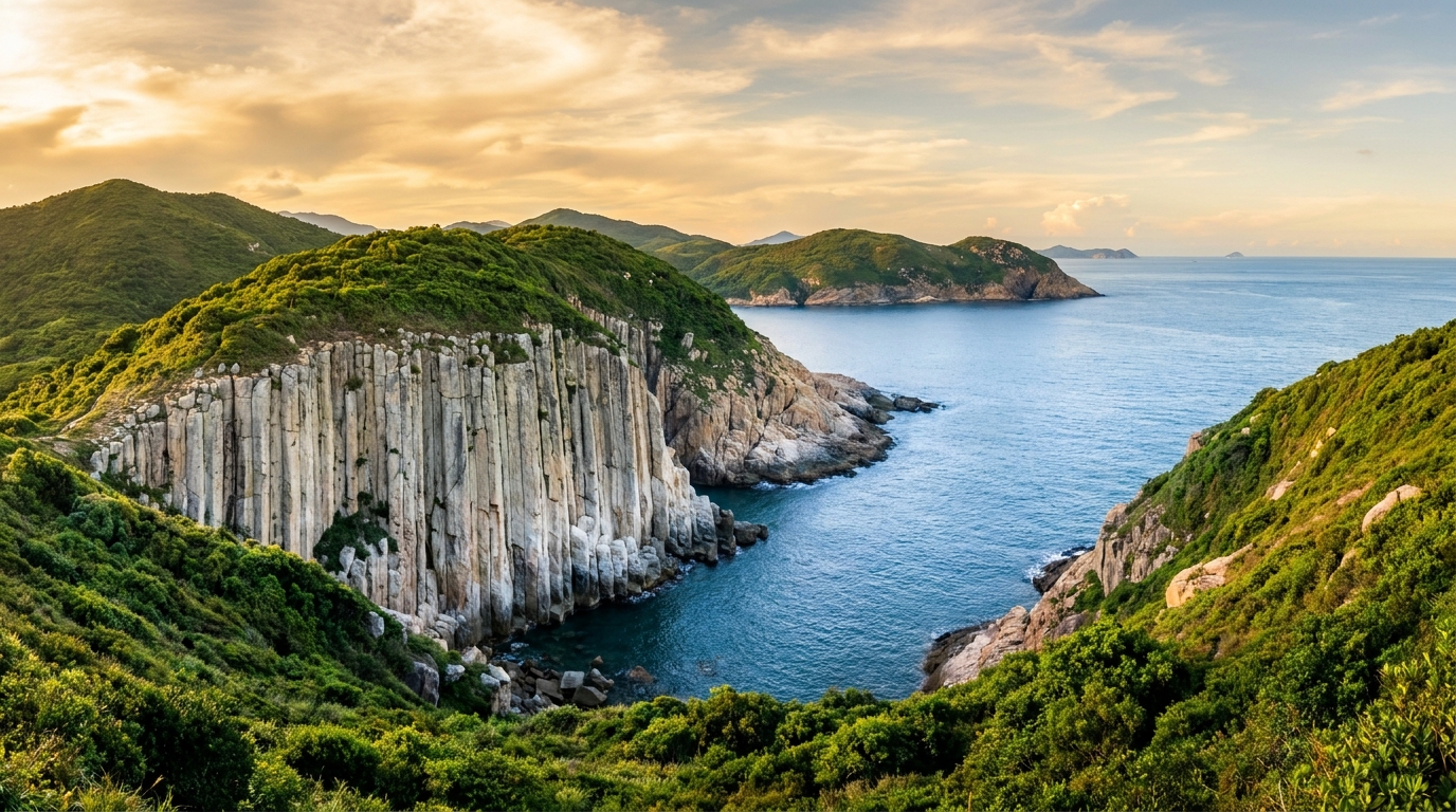
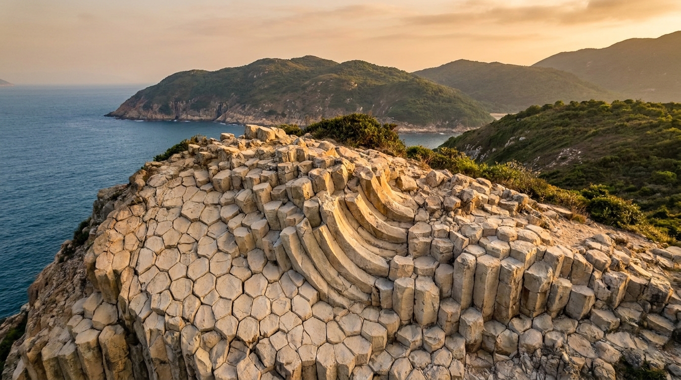
What unites them is geology. Like the rest of the geopark, the Ninepin Group is built from rhyolitic volcanic rock that cooled and contracted into regular polygonal columns about 140 million years ago. Here, fully exposed to the ocean, the sea has stripped the islands back to bare rock, revealing those columns in some of the cleanest, most dramatic displays anywhere in the region.
A showcase of hexagonal columns
If the High Island East Dam is the place to study the columns at arm’s length from land, the Ninepin Group shows them in their wildest natural setting. Sea cliffs of tightly packed pillars plunge straight into deep water; isolated stacks rise like bundles of organ pipes; and in places the columns fan, tilt and curve where ancient earth movements deformed them.
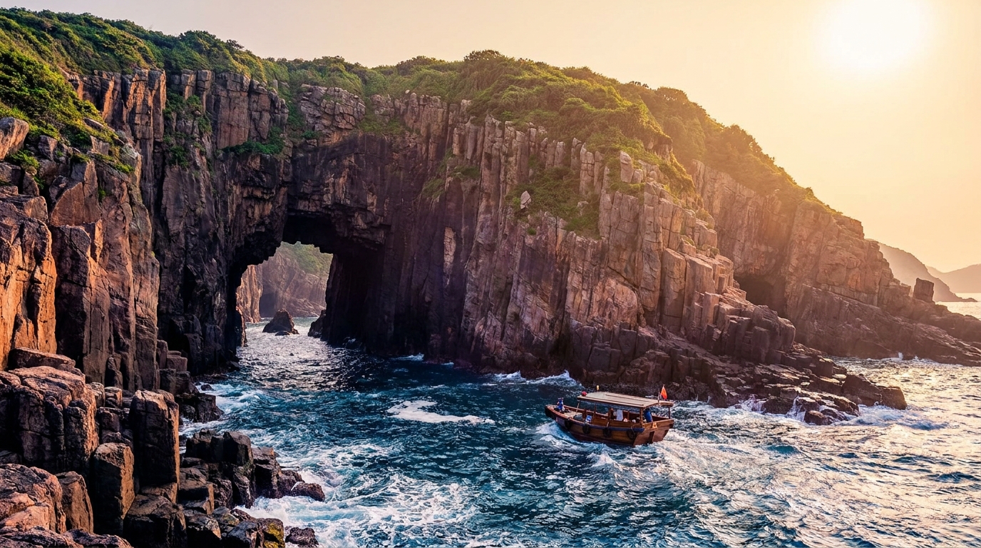
Because nothing shelters these islands, wave erosion has been relentless, peeling away weathered material to expose fresh, sharply defined columns. The effect is a coastline that looks almost architectural — ranks of vertical pillars marching along the cliffs, occasionally broken by caves, notches and small arches where the sea has exploited the joints between them. To understand exactly how and why the rock split into these shapes, see our hexagonal columns explainer.
Look closely and you’ll see the columns are not all identical. Where the lava cooled evenly, the pillars are tall, straight and near-perfectly six-sided; where cooling was uneven or later earth movements intervened, they bend, taper or fan out into curtain-like sweeps. The pale rhyolite weathers to soft greys and golds, streaked with rust-coloured stains and patches of lichen, so that in the low light of early morning or late afternoon the whole coastline takes on a warm glow. It is a reminder that, for all their geometric regularity, these are living landscapes still being shaped by the sea.
Why so remote and exposed?
The Ninepin Group’s isolation is precisely what makes it special — and what makes it hard to reach. Sitting in open water with no landmass to break the swell, the islands experience powerful waves and strong winds for much of the year. That same exposure is what keeps the rock so clean and the columns so vividly displayed, but it also means the sea around them can be dangerous and unpredictable.
Birdlife and ecology
Beyond the geology, the remoteness of the Ninepin Group makes it valuable habitat. The undisturbed cliffs and islets are important roosting and breeding grounds for seabirds, and the surrounding waters draw fish and other marine life. From a tour boat you may spot seabirds wheeling around the stacks or perched on inaccessible ledges. As with all the outer islands, the rule is simple: observe from a respectful distance and disturb nothing — these are fragile, hard-to-monitor ecosystems.
How to get there: boat tours only
There is no pier, no regular ferry and no way to land on the Ninepin Group. Visiting means joining a licensed geo-tour boat, and only when the sea is calm.
| Option | Suitability | Notes |
|---|---|---|
| Licensed geo-tour boat | The realistic option for visitors | From Sai Kung Town; calm-weather days only |
| Experienced sea kayak | Expert paddlers only | Long, fully exposed open-water crossing — high risk |
Most tours bundle the Ninepin Group with other outer-island highlights such as the Ung Kong Group and its sea caves, and the sea stack of Po Pin Chau near the East Dam, into a half- or full-day voyage. When booking:
- Choose a licensed operator with a vessel suited to open water.
- Confirm the weather and cancellation policy — trips here are frequently postponed for swell.
- Ask whether the Ninepin Group is actually included; some shorter tours stay closer to shore.
To get to Sai Kung Town for your boat, see the transport guide. Remember there is no MTR station in Sai Kung — you’ll arrive by bus or minibus from the city.
Best time to go
The Ninepin Group is realistically accessible only on calm, clear days with minimal swell. Autumn and spring generally offer the most settled seas and the best chance of a tour going ahead; the summer typhoon season and the windy winter monsoon both stir up the open water. Even on a fine day in town, conditions offshore can differ — trust the operator’s judgement. Our best time to visit Sai Kung guide covers the seasons in more detail.
Safety on the open water
This is genuinely exposed ocean, and caution comes first:
- Never attempt the trip in a private small boat or by inexperienced kayak.
- Wear a life jacket throughout the voyage.
- Be ready for a bouncy ride; bring motion-sickness remedies if you are prone to seasickness.
- Carry water, sun protection and a windproof layer — there are no facilities and the open sea is breezy even in summer.
- Follow all instructions from the boatman, who knows where it is safe to approach.
Itinerary ideas
Because reaching the Ninepin Group requires a dedicated boat trip in good weather, it makes most sense as part of a wider outer-islands geo-tour. A classic full-day voyage from Sai Kung links the Ninepin Group, the sea caves and arches of the Ung Kong Group, and the towering Po Pin Chau sea stack — a single trip through the most spectacular volcanic coastline in Hong Kong. End the day with a seafood dinner back on the Sai Kung Town waterfront, the open sea behind you.
Frequently asked questions
How do I get to the Ninepin Group?
Only by boat. There are no piers or regular ferries, so visitors join a licensed geo-tour from Sai Kung Town, and only on calm days — the islands sit fully exposed to the open sea.
What makes the Ninepin Group special?
It is one of the finest displays of hexagonal volcanic columns in the geopark, with sea cliffs and stacks of pillars rising directly from the open ocean, plus important seabird habitats.
Can I land on the islands?
No. The Ninepin Group has no safe landing, beaches or facilities; tours view the columns and cliffs from the water and do not put passengers ashore.