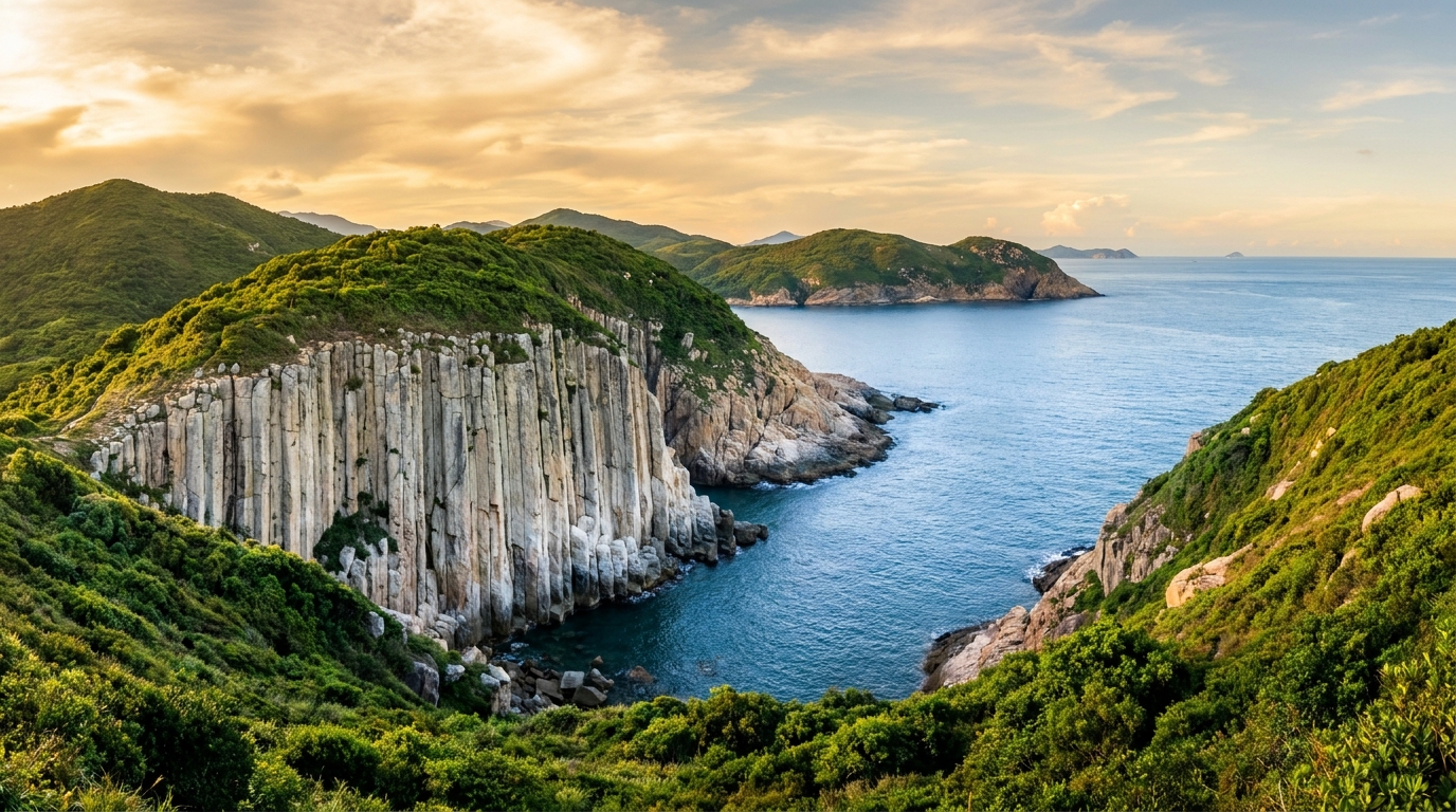
If you visit only one part of the Hong Kong UNESCO Global Geopark, make it the High Island Reservoir East Dam. Nowhere else on Earth can you stand so close to the geopark’s famous rhyolitic hexagonal rock columns — they rise straight from the roadside cliffs, an arm’s length away, in ranks so regular they look carved by hand rather than by a cooling volcano.
A reservoir that revealed a geo-wonder
The story of the East Dam is a happy accident of engineering. By the late 1960s, fast-growing Hong Kong was desperately short of fresh water. The solution was bold: rather than flood a valley, engineers decided to dam a sea channel. In the 1970s they built two enormous dams — a West Dam and an East Dam — to seal the strait between the mainland and High Island (Leung Shuen Wan), turning a salty inlet into the High Island Reservoir, then the territory’s largest freshwater store. Seawater was pumped out and the basin refilled with rainwater.
To build the East Dam, stone was quarried from the cliffs around the site, and the excavation sliced clean through the volcanic rock. What it exposed was extraordinary: cross-sections of globally rare rhyolitic volcanic hexagonal rock columns, formed about 140 million years ago and never before seen so clearly. What began as a waterworks project accidentally created the best place on Earth to study this geo-wonder at close range. For the full science of how the pillars formed, see our hexagonal columns explainer.
What to see at the East Dam
The East Dam packs more geological drama into a short stretch than almost anywhere in Hong Kong. Highlights include:
The hexagonal columns and S-bent folds
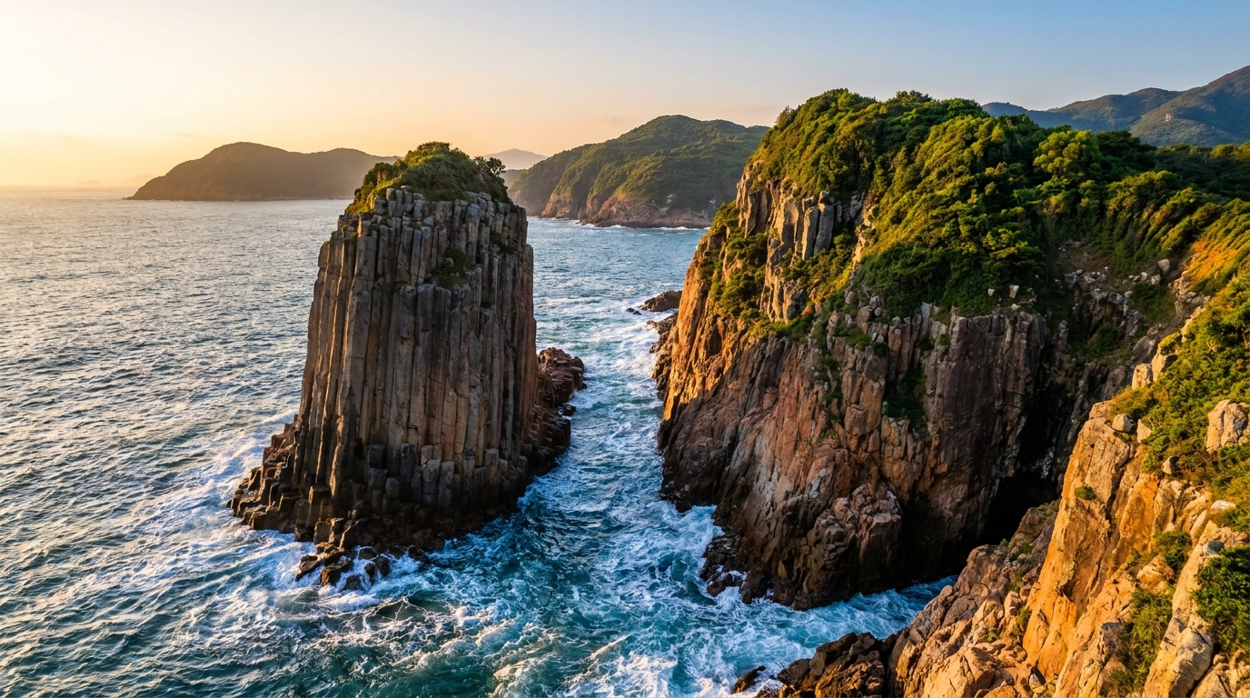
Towering, regular polygonal pillars line the roadside cliffs in tight formation, each averaging just over a metre across and reaching tens of metres up the rock face. The showstopper is the famous S-shaped fold — a section where ancient earth movements bent the once-vertical columns into a sweeping curve. It is one of the most photographed geological features in Hong Kong, and a textbook illustration of how solid rock can deform under immense pressure over time.
The sea arch and sea cave
A short walk from the dam leads to a wave-cut sea arch carved straight into the volcanic rock by millennia of pounding surf. Nearby, a sea cave / blowhole funnels incoming swells; on rough days the waves surge and boom into the cave below the viewing area, sending up spray.
Po Pin Chau
Just offshore, the island of Po Pin Chau is the dam’s most dramatic neighbour — a sheer-sided stack split from the headland by erosion, its cliff face a solid wall of columns. It is one of the iconic views from the dam area and a classic stop on geo-tour boat trips.
The dolosse
On the seaward face of the dam sit thousands of dolosse — chunky, interlocking concrete blocks shaped a little like jacks or anchors. Stacked in a loose, random-looking armour, they absorb and scatter the force of waves rolling in from the open South China Sea, protecting the dam wall. They also make a striking foreground for photographs.
Reservoir views
Turn inland and the mood flips completely: the calm, deep-blue freshwater reservoir stretches away in serene contrast to the wild, exposed coast on the seaward side.
An interpretation panel and the High Island Geo Trail guide you through the geology as you walk, explaining the columns, the folds and the coastal erosion features.
How to get there
The East Dam is remote and not served by any public bus. Plan your transport before you go. Your main options:
| Method | From | Notes |
|---|---|---|
| Taxi / village taxi | Sai Kung Town | Simplest; arrange a round trip with waiting time |
| Hike | Pak Tam Chung via MacLehose Trail Sec 1 | ~10 km along the reservoir; for the fit |
| Geo-tour boat | Sai Kung Pier | Combines the dam, sea caves and Po Pin Chau |
- Taxi / village taxi from Sai Kung Town is the easiest choice. Because private vehicles are restricted at the dam on weekends and public holidays, a taxi or hired “village taxi” is often the only way to drive in on busy days — arrange a round trip with an agreed waiting time so you are not stranded.
- Hike in along MacLehose Trail Section 1 from Pak Tam Chung, following the reservoir for around 10 km. It is a rewarding, scenic walk for the reasonably fit, ending right at the dam.
- Geo-tour boat from Sai Kung, which combines the dam coastline with the nearby sea caves, arches and Po Pin Chau — the best way to see the columns from the water.
See the full transport guide for connections from the city to Sai Kung Town first.
Best time and practical tips
Visit on a clear, calm day for the best light and safest footing; the columns and the South China Sea look their finest under blue skies. Mornings tend to be cooler and quieter. Allow 1.5 to 2 hours to explore the dam top, the sea arch and the Geo Trail at an unhurried pace.
Crucially, there is little shade and no shop, no toilet supplies and no drinking water at the dam. Come prepared:
- Carry plenty of water — there is nowhere to refill.
- Bring a hat, sunscreen and sunglasses; the exposed concrete and pale rock reflect a lot of heat and glare.
- Wear sturdy, grippy shoes for the trail and rock surfaces.
- Avoid the blowhole and lower rocks in rough seas — rogue waves can surge without warning.
Nearby and itinerary ideas
The East Dam pairs naturally with the rest of the volcanic region. From the water, link it with Po Pin Chau and the offshore sea caves on a geo-tour. On foot, continue along the MacLehose Trail toward the beaches of Tai Long Wan. Or keep it simple and round off the day with a seafood dinner back in Sai Kung Town. However you build it, standing beside the East Dam’s 140-million-year-old columns is one of the most extraordinary things you can do within an hour of a major city.
Frequently asked questions
How do I get to the East Dam?
There is no public bus. From Sai Kung Town take a taxi or hired ‘village taxi’ to the dam, or hike in via the MacLehose Trail from Pak Tam Chung. Private cars are restricted on weekends and public holidays.
Is the East Dam suitable for children and seniors?
Yes — the dam top and the Geo Trail are largely flat and paved, making it one of the more accessible geopark sites. Bring sun protection as there is little shade and no water on site.
What is the dolosse structure on the seaward side?
Those interlocking concrete blocks are ‘dolosse’, placed to absorb the force of waves and protect the dam from the open South China Sea.