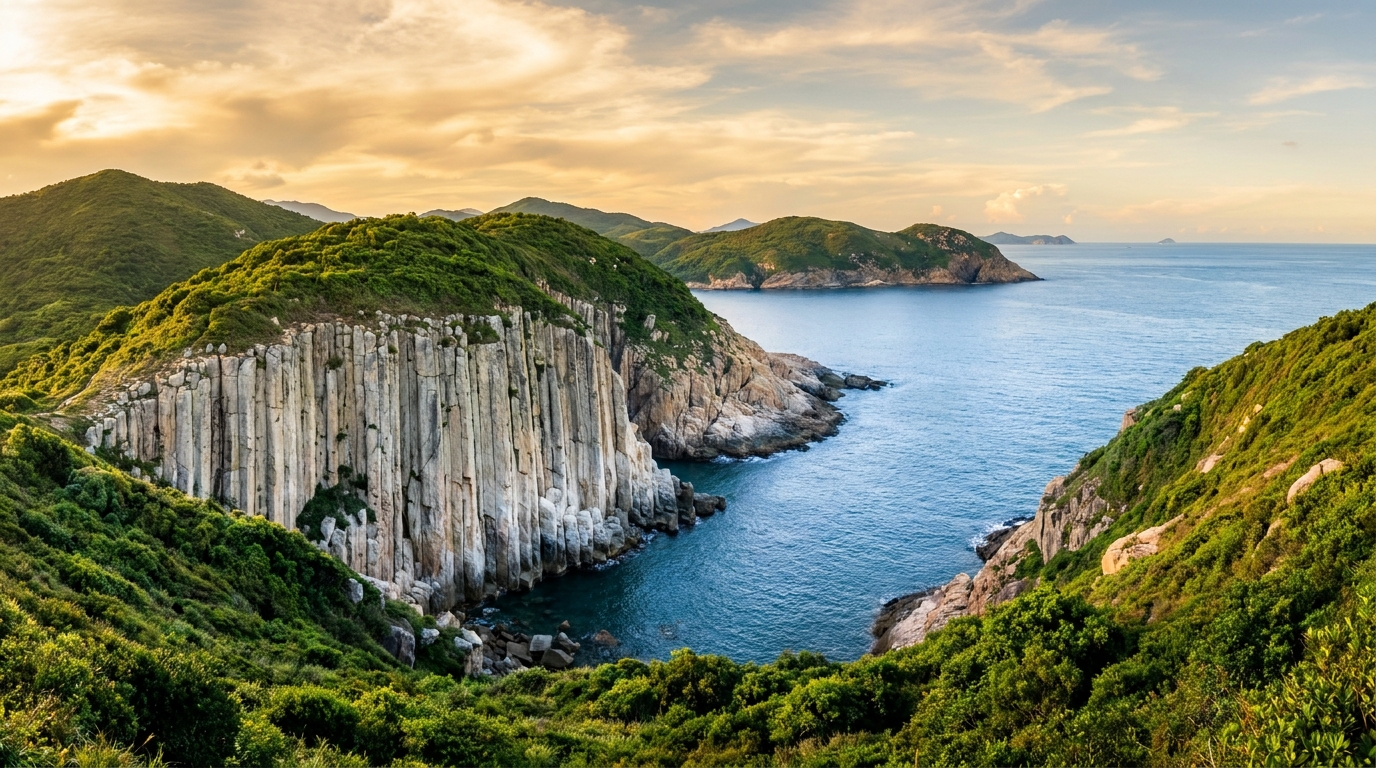
Stand on the seaward edge of the High Island Reservoir East Dam, look out across a narrow channel, and you’ll see one of Hong Kong’s most arresting natural sights: Po Pin Chau, a sheer-walled island whose entire face is a solid sweep of vertical hexagonal columns. What makes it so striking is that it was once part of the headland you’re standing on — the sea has simply sliced it off.
A stack split from the headland
Po Pin Chau (破邊洲) is a sea stack: an isolated pillar of rock left standing offshore after the sea cut it away from the coast. Its name in Cantonese hints at the story — po pin meaning, loosely, “broken edge.” A narrow channel of churning water now separates the stack from the mainland headland near the East Dam, but the two were once joined.
The island is essentially a single great wall of rhyolitic volcanic columns, the same pale, silica-rich pillars that made the Sai Kung geopark world-famous. They run vertically up its cliff face in tight, regular ranks — so clean and parallel that the whole stack looks like a giant bundle of pipes rising from the sea. For the full science of why the lava cooled into these hexagonal shapes some 140 million years ago, see our hexagonal columns explainer.
How Po Pin Chau formed: cave, arch, stack
Po Pin Chau is a textbook example of how the sea dismantles a columnar coast, step by step:
- Lines of weakness. The volcanic columns are separated by natural vertical joints, and crossed by horizontal fractures. These cracks are where the rock is weakest.
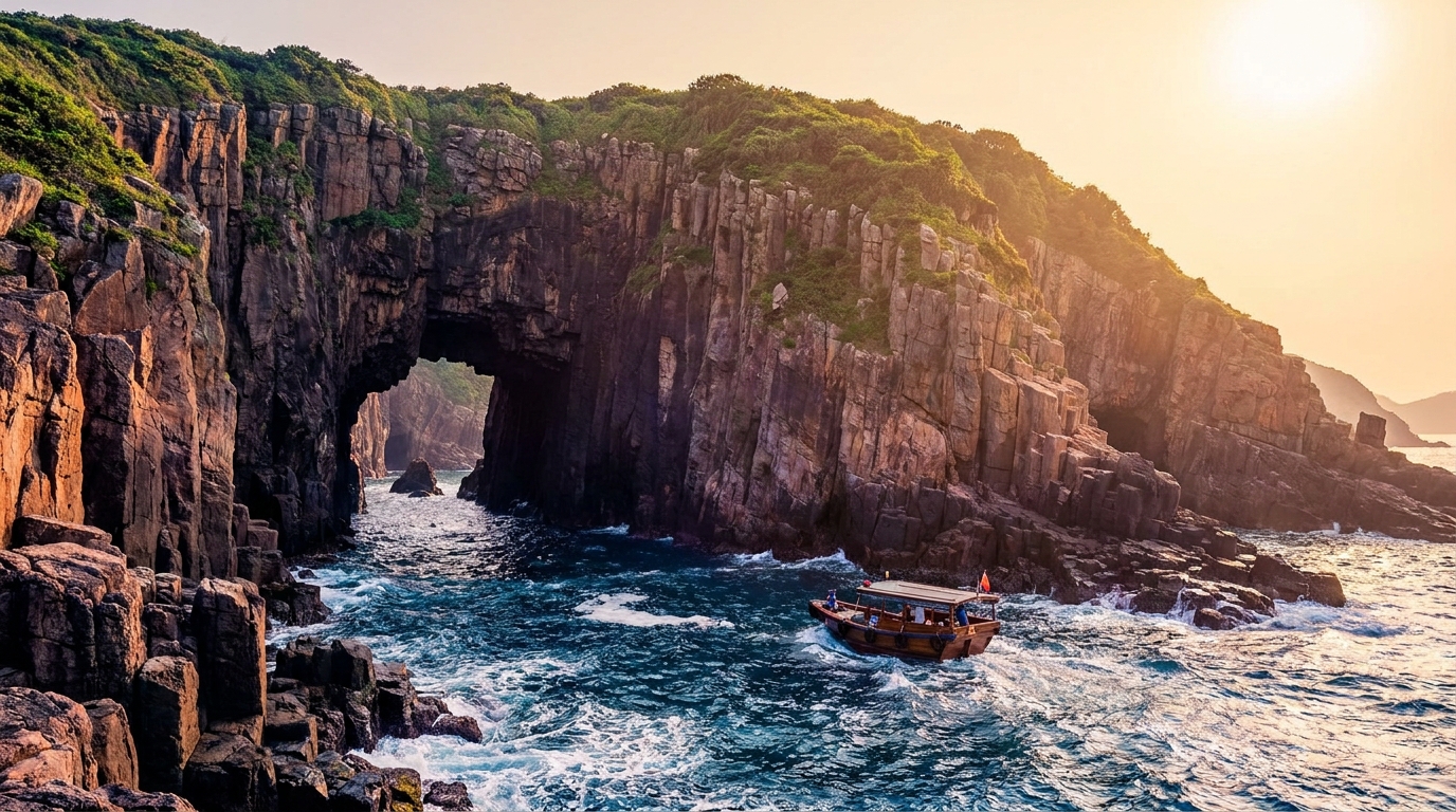
- A sea cave. Waves attack a joint at the base of a headland, hollowing out a sea cave along the line of least resistance.
- A sea arch. As the cave deepens and breaks through a narrow neck of land, it becomes a sea arch — a bridge of rock with open water passing beneath.
- Collapse to a stack. Eventually the arch’s roof, unsupported, collapses. The far portion of the headland is left standing alone offshore as a sea stack — Po Pin Chau.
Given enough time, the sea will keep eroding the stack until it too crumbles into a low stump and finally disappears. Po Pin Chau, then, is a single frozen frame in a process that is still running. The same forces are at work on the caves and arches of the nearby Ung Kong Group, which show earlier stages of exactly this sequence.
What you’ll see
The drama of Po Pin Chau is all in its verticality. From the right angle, the channel between stack and headland lines up into a dead-straight corridor of water walled on both sides by towering columns — a view that has become one of the iconic images of the geopark. The pale rock glows in low sunlight, and on rough days the swell funnels and surges through the gap below.
It is, above all, a place to look and photograph rather than touch. There is no landing, no beach and no trail on the stack itself; its sheer columnar walls drop straight into deep, moving water.
How to see it
There are two ways to take in Po Pin Chau, and they show it very differently.
| Viewpoint | How | What you get |
|---|---|---|
| East Dam clifftop | Short path from the High Island East Dam | The classic top-down channel view; combine with the dam’s columns, sea arch and blowhole |
| Geo-tour boat | Licensed boat from Sai Kung Town | A head-on, sea-level view of the full columnar face, often with the outer islands |
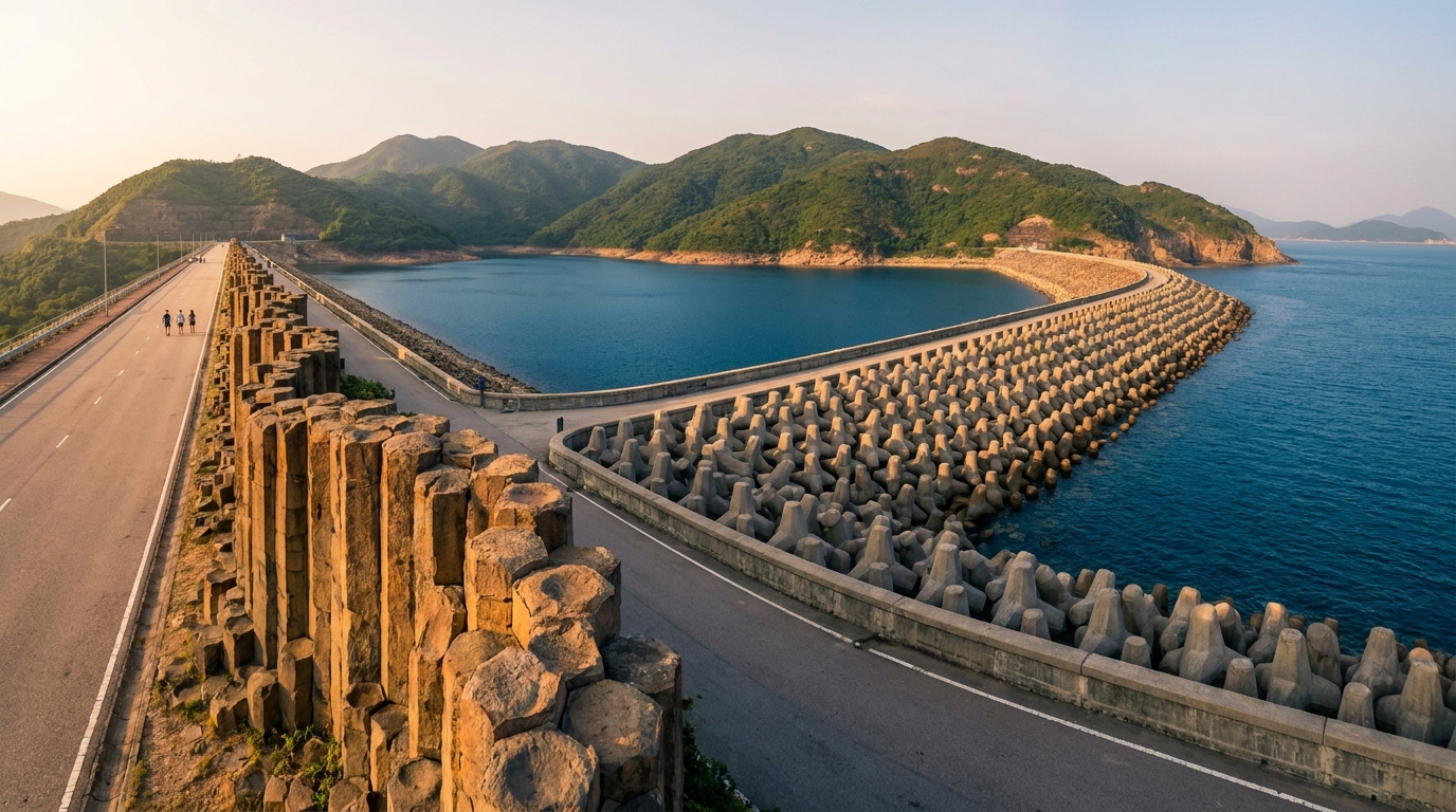
From the East Dam clifftop
The simplest option is on foot. From the East Dam, a short clifftop path leads to a viewpoint over the stack — letting you stand on the very headland Po Pin Chau was severed from and look across the channel. This pairs perfectly with the dam’s other wonders: the famous S-bent columns, the sea arch and the blowhole. To reach the dam itself you’ll need a taxi, village taxi or a hike from Pak Tam Chung, since there is no public bus — full details are in the East Dam guide.
By geo-tour boat
For the most dramatic perspective, see Po Pin Chau from the water. Licensed geo-tour boats from the Sai Kung public pier pass close to the stack, giving a head-on view of the full sweep of columns rising from sea level — and they often combine it with the sea caves of the Ung Kong Group and other outer islands.
To get to Sai Kung in the first place, see the transport guide; remember there is no MTR station in Sai Kung, so you’ll connect by bus or minibus from the city.
Best time and practical tips
Visit on a clear, calm day for the best light and the safest footing on the exposed clifftop. Autumn and spring offer the most comfortable, settled weather — see our best time to visit Sai Kung guide. A few practical points:
- The East Dam area has little shade and no shops or water — carry plenty of water, a hat and sun protection.
- Wear sturdy, grippy shoes; the clifftop edges are rocky and exposed.
- Keep well back from cliff edges, especially in wind, and never scramble down toward the channel.
- If viewing by boat, follow the boatman’s instructions and wear a life jacket; the channel water can surge.
Itinerary ideas
Po Pin Chau is best enjoyed as the showpiece of an East Dam visit or an outer-islands boat tour. On land, combine it with the full sweep of the High Island East Dam — columns, arch and blowhole — for a half-day on the geopark’s signature coast. By sea, fold it into a voyage taking in the sea caves of the Ung Kong Group. Either way, finish with a seafood dinner back in Sai Kung Town, having watched the sea quite literally carve an island in two.
Frequently asked questions
How do I see Po Pin Chau?
The easiest way is on foot from the High Island Reservoir East Dam, where a short clifftop path overlooks the stack. For a head-on view of the columns, join a geo-tour boat from Sai Kung Town.
How was Po Pin Chau formed?
Waves eroded along the natural joints between the hexagonal volcanic columns, first carving a sea cave, then an arch, which finally collapsed — leaving the island severed from the headland as a sea stack.
Can I land on Po Pin Chau?
No. Po Pin Chau is a sheer-sided stack with no landing place; it is viewed from the East Dam clifftop or from a boat passing through the channel.