The Hong Kong UNESCO Global Geopark is one of the territory’s most remarkable natural assets — a place where a violent volcanic past, some 140 million years deep, is written into the cliffs and headlands of Sai Kung. Most visitors arrive expecting a city of skyscrapers and harbour lights; few realise that a 40-minute journey from the urban core leads to a coastline of towering rock organs, sea arches and folded stone that geologists travel across the world to study.
What the geopark is
The geopark was established to protect and interpret rock formations of outstanding scientific value, and it joined UNESCO’s Global Geoparks Network in recognition of their global significance. It is not a fenced theme park but a network of protected coastal and inland sites spread across eastern and northeastern Hong Kong, woven into existing country parks and marine waters. You explore it on foot, by boat and by trail rather than through a single gate.
The park is divided into two distinct regions, each telling a different chapter of Hong Kong’s deep history:
- The Sai Kung Volcanic Rock Region, the star of the show, preserves the hexagonal rhyolitic columns formed by an ancient supervolcano.
- The Northeast New Territories Sedimentary Rock Region preserves layered sedimentary rocks — sandstones, shales and even fossil-bearing strata — that record hundreds of millions of years of changing seas, deserts and deltas.
This guide focuses on the Sai Kung Volcanic Rock Region, because it is the part most travellers come to see and the part most easily reached from Sai Kung Town.
A globally rare wonder
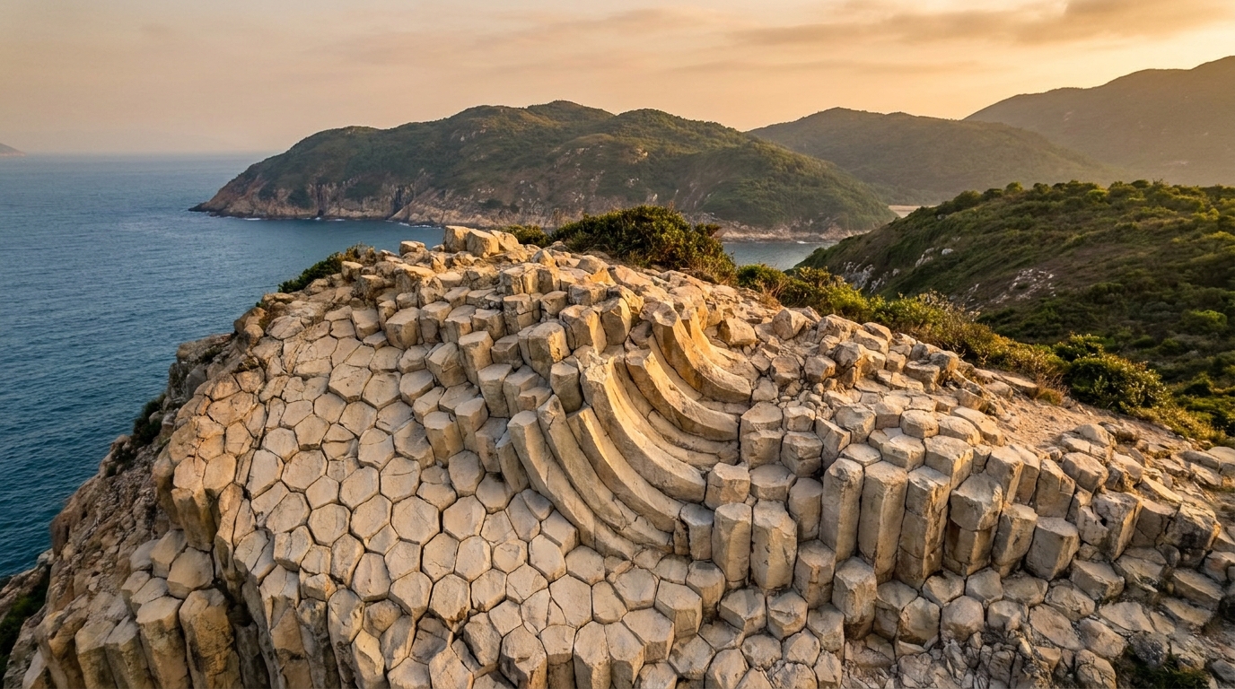
Hexagonal rock columns exist in famous places around the world — the Giant’s Causeway in Ireland, Devils Postpile in California, Fingal’s Cave in Scotland — but almost all of them are dark-grey basalt with low silica content. Sai Kung’s columns are fundamentally different. They are made of light-coloured rhyolitic volcanic rock that is rich in silica, and that single fact is what makes them globally rare. Rhyolite is far more viscous and silica-heavy than basalt, so columnar jointing on this scale is unusual; finding it spread across an entire coastline is rarer still.
And the scale here is the headline. Sai Kung’s columns cover an astonishing 100 square kilometres — the largest coverage area of acidic (silica-rich) columnar rock anywhere on Earth. Individual columns reach tens of metres in height and average roughly 1.2 metres across, standing in tight, near-perfect ranks like the pipes of a colossal stone organ.
In recognition of their significance, the Early Cretaceous rhyolitic columnar rock formation was selected as one of the First 100 IUGS (International Union of Geological Sciences) Geological Heritage Sites — a global shortlist that places Sai Kung alongside the most important geological landmarks on the planet. For a deeper dive into the science, see our dedicated hexagonal columns explainer.
How the columns formed
Around 140 million years ago, during the Early Cretaceous, a massive volcano erupted in what is now Sai Kung. This was no gentle lava flow. The eruption produced enormous volumes of thick, super-hot volcanic ash and pyroclastic material that blanketed the landscape and collapsed back into the volcano’s own caldera. As this immense sheet of ash settled and cooled very slowly and evenly, it contracted. Contracting rock cracks, and when cooling is slow and uniform the cracks organise themselves into the most efficient pattern possible — regular polygons, mostly hexagons. Propagating downward through the cooling rock, these cracks carved out the vertical columns we see today.
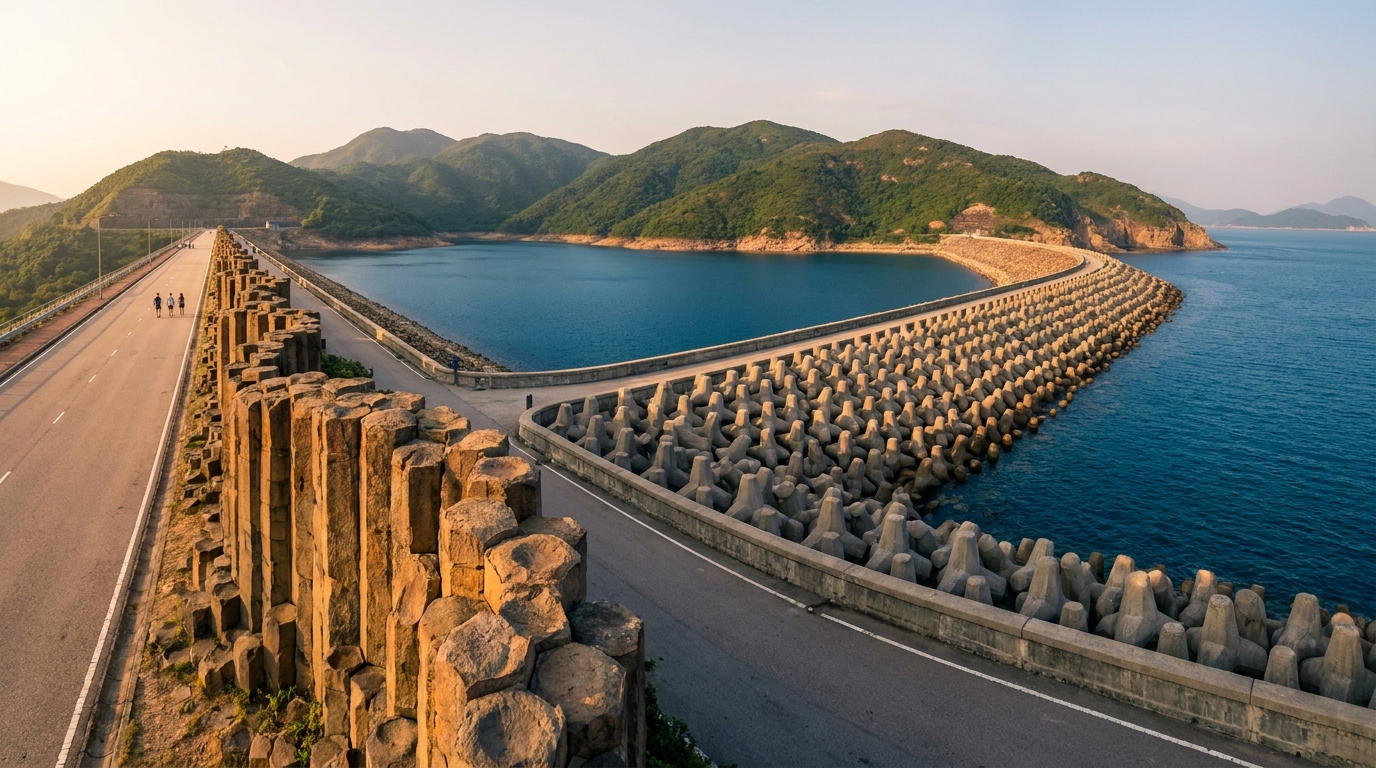
Long after the rock had set, the story continued. Later earth movements tilted, folded and even S-bent some of the columns, twisting pillars that were once ramrod-straight. These deformations — best seen at the East Dam — are a vivid reminder that the seemingly solid ground beneath Hong Kong has been pushed, squeezed and reshaped over geological time. Millions of years of relentless wave action then sculpted the exposed coastline into the sea caves, arches and stacks that punctuate the columns today.
What to see
The volcanic region’s highlights are spread along the coast and offshore islands. Here is how the key sites compare:
| Site | What makes it special | How to reach it |
|---|---|---|
| High Island East Dam | Stand beside the columns; S-bent folds, sea arch, blowhole | Taxi / village taxi or hike from Pak Tam Chung |
| Sharp Island | Tombolo sandbar, “pineapple bun” rock | Short kaito ferry from Sai Kung Pier |
| Ung Kong Group | Sea caves, arches, towering column cliffs | Geo-tour boat |
| Ninepin Group | Dense columnar islets, dramatic cliffs | Geo-tour boat (sea conditions permitting) |
High Island Reservoir East Dam
If you see only one site, make it the High Island Reservoir East Dam. It is the single best place on Earth to stand within arm’s reach of the columns, complete with a wave-cut sea arch, a coastal blowhole and the famous S-shaped folds.
Sharp Island
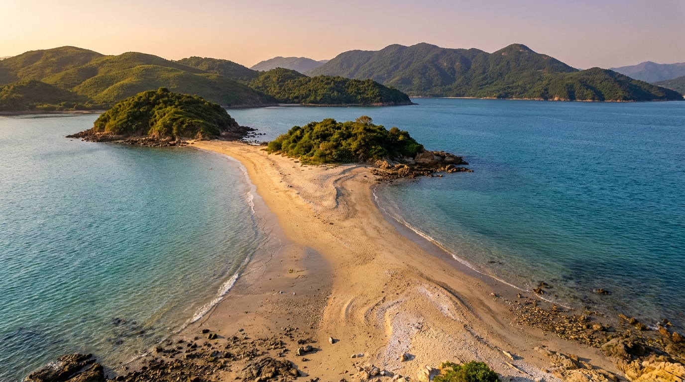
The most accessible volcanic site, Sharp Island (Kiu Tsui Chau) sits just offshore and is reached by a short kaito ferry. At low tide a natural tombolo — a sandbar of broken rock — links it to a smaller islet, and you can walk across.
Ung Kong and Ninepin Groups
For sheer drama, the offshore Ung Kong Group and Ninepin Group offer sheer column cliffs, deep sea caves and arches best appreciated from a licensed geo-tour boat. These trips depend on sea conditions and are not for the prone to seasickness.
How and where to visit
Almost every geopark trip begins in Sai Kung Town, the gateway hub for buses, minibuses, taxis and the kaito ferries. There is no MTR station in Sai Kung; the usual approach is KMB bus 92 from Diamond Hill, or green minibus 1A from Choi Hung, both detailed in our transport guide.
From town, your options branch out:
- By taxi / village taxi to the High Island East Dam (private cars are restricted on weekends and public holidays).
- By kaito ferry from the public pier to Sharp Island and other islands.
- On foot along the MacLehose Trail Section 1, which runs past the reservoir from the Pak Tam Chung trailhead.
- By geo-tour boat for the Ung Kong and Ninepin Groups.
The Volcano Discovery Centre near Sai Kung Waterfront is a worthwhile first stop for context before you head out.
Visiting responsibly
The geopark is a protected area, and its features took 140 million years to make. Treat them gently:
- Stay on marked paths and viewing platforms.
- Take all litter home — many sites have no bins and no shops.
- Do not hammer, climb on, or remove rock samples. Collecting is prohibited.
- Use licensed boat operators for island and sea-cave trips.
Many sites are remote and exposed, with little shade and no fresh water. Check the weather and tide before you go, carry plenty of water and sun protection, wear sturdy shoes, and tell someone your plans. Avoid the coast entirely in rough seas or when a typhoon signal is in force.
Planning your visit
Pair a geopark day with a seafood lunch in Sai Kung Town, a stroll on the Pak Tam Chung Nature Trail, or a longer walk on the MacLehose Trail. However you piece it together, the Sai Kung Volcanic Rock Region rewards a slow, curious traveller — every cliff here is a page from one of the most dramatic chapters in Earth’s history, hidden in plain sight just beyond the city.
Frequently asked questions
Why are Sai Kung's rock columns special?
Most hexagonal columns worldwide are dark basalt. Sai Kung’s are pale, silica-rich rhyolite — far rarer — and they cover about 100 km², the largest such expanse on Earth. The formation was named one of the IUGS’ First 100 Geological Heritage Sites. Learn more in our hexagonal columns explainer.
How old are the rock columns?
They formed around 140 million years ago in the Early Cretaceous, when a supervolcano’s thick rhyolitic ash cooled slowly and contracted into the characteristic polygonal columns.
Where can I see the columns up close?
The best close-range viewpoint is the High Island Reservoir East Dam. The columns are also visible around Sharp Island, the Ung Kong Group and the Ninepin Group by boat.